Friday, February 28, 2014

Beavertail Lighthouse, Jamestown (Newport) Rhode Island

Got to this light as part of the Newport Lighthouse Boat Tour, one of 10 on the tour. 


The shot I took on the tour
Beavertail Lighthouse, built in 1749, was and still is the premier lighthouse in Rhode Island, USA, especially for entrance into Narragansett Bay. The 45-foot (14 m) lighthouse lies on the southernmost point of Conanicut Island in the town of Jamestown, Rhode Island in Beavertail State Park. The light has been reconstructed multiple times since its erection, most recently after the Hurricane of 1938. Restoration projects have come and gone since. The light provides navigation for boats and ships entering Narragansett Bay in the East Passage between Conanicut Island and Newport, Rhode Island on Aquidneck Island. Other lighthouses, such as Castle Hill Lighthouse, Point Judith Light, and Rose Island Light are visible from Beavertail Lighthouse.
Its white light rotates counterclockwise and makes a full rotation in about six or seven seconds. The light is on 24 hours per day, unlike many lighthouses that are near it. It has a loud foghorn that blasts about every 30 seconds during the fog.
History
Prior to the establishment of a lighthouse at Beavertail, local Native Americans would keep pitch fires burning, to warn sailors away from the rocky coastline. In 1749, a wooden tower was built, and the light (which was then known as "Newport Light") became the third lighthouse established in the colonies, preceded only by Boston Light in Boston Harbor, and Brant Point Light, Nantucket. A fire was lit at the top of the tower, as was common for the time. Four years later it burned down and was replaced by a stone tower.
In 1779, as British sailors retreating from Newport near the end of the American Revolutionary War, they left a trail of destruction behind them. This included burning the lighthouse and removing the optics, which left the light dark for the rest of the war.
In 1856, the tower was again replaced with what is now the current tower, made of granite which is 10 ft (3.0 m) square, and 64 feet (20 m) from ground to beacon. A 3rd order Fresnel lens was placed and over the next forty years it was the site of numerous fog-signal tests, under the supervision of the United State Lighthouse board. In 1898 quarters for an assistant keeper were added to the keeper's house, the assistant helped, among other things, with fog-signaling.
During the 1938 hurricane, the whistle house was destroyed, revealing the original base for the 1749 structure, which sits 100 feet (30 m) from the current tower. A few miles southwest of Beavertail point, Whale Rock can be seen, resembling a submarine attempting to surface. Whale Rock Lighthouse, and its keeper, Walter Eberle, were swept into the waters of Narragansett bay during the hurricane of 1938; Eberle's body was never recovered.
In 1939, the US Coast Guard took command of all lighthouses and navigational aids, and in 1989 Beavertail light was automated, as part of a program by the Coast Guard, which ended the job the keeper at all stations except for Boston Light, which to this day, remains the only manned lighthouse in America.
In 1989, following a joint effort by the US Coast Guard, Rhode Island Parks Management, the Rhode Island Department of Environmental Management, and the town of Jamestown, the building was restored and reopened to the public. In 1993, Beavertail Lighthouse Museum Association (BLMA) was established to oversee the operations of the Beavertail Lighthouse Museum, which is located in the assistant keeper's house. The museum includes a Fresnel lens, and the history of, models and photos of many Rhode Island lighthouses.


Boon Island Light, Near Portsmouth New Hampshire

This light is viewed as part of a boat trip out to the Isle of Shoals off the coast of Portsmouth, New Hampshire.  Made the trip a couple of times, once with both the grandsons, and once with Porter and Bill.  The light is only visible by water.  The stamp is at the Cape Neddick (Nubble) Light house in Maine. 


Boon Island Light is located on the 300-by-700-foot (91 m × 213 m) Boon Island off the southern coast of Maine, United States, near Cape Neddick. Boon Island Light has the distinction of being the tallest lighthouse in both Maine and New England at 133 feet (41 m). The lighthouse has a focal plane at 137 feet (42 m) above mean high water. The light's beacon flashes white every 5 seconds.
Talk of building a lighthouse on Boon Island dates back as early as 1710 when the ship Nottingham Galley ran aground on the barren outcrop that makes up the island. The crew of the Galley were forced to resort to cannibalism before being rescued. In 1799 the first day marker and the station itself were established on the island. In 1811 the station was converted to a full light station and a granite tower was constructed. The first tower along with a subsequent replacement were both washed away in storms.
The current cylindrical brown granite tower was constructed in 1855 and originally had a second order Fresnel lens installed. Boon Island Light suffered extensive damage in a blizzard in 1978. Several stones that make up the tower itself were washed into the sea as were all of the keepers dwellings and other outbuildings that had been on the island. As a result the station was automated in 1980 and a solar powered beacon was installed by the United States Coast Guard. The station is currently active and controlled by the Coast Guard while the lighthouse itself is on lease to the American Lighthouse Foundation. The lighthouse was listed on the National Register of Historic Places as Boon Island Light Station on March 14, 1988, reference number 88000153.[4]
Historical information from Coast Guard web site:
President James Madison authorized the building of Boon Island Lighthouse during the War of 1812. A new lighthouse tower was erected near the old tower in 1855, consisting of a gray granite conical tower, 133 feet above the water, 6.2 nautical miles (11.5 km; 7.1 mi) off the coast of Maine.
As Boon Island is a very flat piece of land, well surrounded by ledges, the tower appears at times to be springing up from the sea from a submerged ledge, especially when low clouds are flying. One of the most isolated stations off the Maine coast, it is also one of the most dangerous.
One story is told of how the keepers were once marooned on the island for several weeks because of storms and rough weather. Their food supplies were low and starvation seemed to be staring them in the face. Just at the point of desperation a boat appeared and they signaled for help. The keeper’s message in a bottle was picked up by the passing schooner which hove to and anchored until the sea went down. Then the crew packed some food in a mackerel barrel and set it afloat. It drifted right into a little cove on the island and then the sea caught it and bounced it well up on the bank, out of the way of the surf. The hunger of the keepers was appeased until they were able to go ashore and get supplies at the village of York.
During the 19th century a keeper died while on the island leaving his wife alone to tend to the station. She did so until she went insane and was found by a rescue ship wandering the island.
Boon Island Light is not open to the public. The only way to view the tower is by boat or aircraft.


Thursday, February 27, 2014

Presque Isle Lighthouse, Erie PA.

Grabbed this this past summer on our way over to New York State and then Maine.  

It was right on the waterfront, part of a big Maritime museum. 


At the City of Erie, a peninsula, over six miles in length, arches out into the water of Lake Erie forming an expansive natural harbor. French explorers recognized the intrinsic value of the harbor and in 1753 constructed Fort Presque Isle on the mainland near the harbor entrance. The name Presque Isle means “almost an island” in French and referred to the nearby peninsula. From Fort Presque Isle, fur traders could portage their goods fifteen miles to Fort Le Boeuf, located at the upper reaches of the Allegheny River near present-day Waterford, and then float downstream to Pittsburgh and on to Louisiana. Fort Presque Isle and its portage thus became a vital link between the French fur trade network in the Great Lakes and its colony on the Gulf Coast.
Control of the Presque Isle region was wrested from the French in 1760 during the French and Indian War, and following the Revolution, the area was incorporated into the State of Pennsylvania in 1792. During the War of 1812, the harbor at Presque Isle was used to construct six warships, including the Brig Niagara, which played a role in Admiral Perry’s convincing victory over the British in the historic Battle of Lake Erie.

The first lighthouse at Erie, and indeed the first American lighthouse on the Great Lakes, was constructed on a mainland bluff in 1818, not far from the site of Fort Presque Isle. For decades, the commercial importance of Erie was directly tied to shipping on the Great Lakes, which increased dramatically in 1824 following the completion of the Erie Canal connecting Buffalo to the Hudson River. The success of New York’s canal prompted Pennsylvania to link Philadelphia to Pittsburgh with a network of canals that opened in 1834. A decade later, the Erie Extension Canal was completed, and Erie was once again a vital link to cities along the Ohio and Mississippi Rivers.
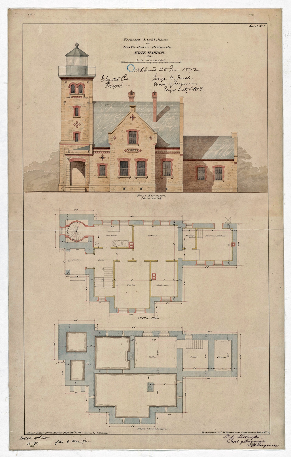
In 1870, plans were begun for a lighthouse on the north shore of the Presque Isle Peninsula that would replace Erie Land Lighthouse on the mainland. This new light would be several miles nearer the lake, and being located directly on the peninsula, would better mark that navigational hazard. Congress appropriated funds for its construction on June 10, 1872, and proposals were solicited for the necessary building materials. The lighthouse was originally going to be built of limestone, but when this provided to be too costly, bricks were used instead.
Construction on the peninsula began in September of 1872, and the light from atop the forty-foot tower attached to the keeper’s dwelling was first exhibited on July 12, 1873. The hazard of landing material at the site was evidenced by the loss of a scow carrying 6,000 bricks.
The walls of the lighthouse tower were built with five courses of brick in order to withstand the fierce storms and buffeting winds that blow off the lake. Though square on the outside, the tower is circular inside and supports a spiral staircase, forged in Pittsburgh and barged to Erie. The brick keeper’s dwelling originally had an oil room, bedroom, dining room, kitchen, and summer kitchen on the main floor, and three bedrooms and a drying room on the second floor. Beneath the dwelling were located a cistern and a cellar. The cost for the lighthouse was $15,000.
Charles Waldo was the first keeper of the Presque Isle Lighthouse, earning an annual salary of $520. On the day of the inaugural lighting, Keeper Waldo wrote, “This is a new station and a light will be exhibited for the first time tonight - there was one visitor.” Prior to sundown, Waldo would have lit the lantern inside the tower’s Fresnel lens and then throughout the night returned to check the oil level in the lamp. In 1882, the tower was equipped with a revolving fourth-order Fresnel lens that alternately produced a red and white flash every ten seconds. Before this, the tower exhibited a fixed white light punctuated each minute by a red flash. As the other lighthouses at Erie displayed fixed lights, the locals often called Presque Isle Lighthouse the “flash light.” The old Erie Land Lighthouse was discontinued in 1880.
In 1876, Waldo’s wife, Mary, gave birth at the lighthouse to a baby girl, the 
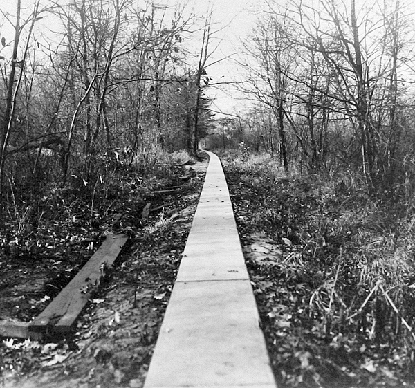
first child to be born on Presque Isle. During their seven-year stay at the lighthouse, the Waldo family had an isolated existence, as the road to the peninsula was not completed until 1927. In fact, Keeper Waldo referred to the station as the loneliest place on earth. To reach civilization, the keepers and their families would have to walk along a 1.5-mile pathway, part of which was originally a boardwalk due to the marshy terrain it traversed, to reach the station’s boathouse on Misery Bay. A lengthy row across the bay and another walk were then required to reach the nearest school or store where provisions could be obtained. The pathway was finally paved in 1925, which led to its being called the “sidewalk trail.”

The Lighthouse Board noted in 1886 that the shoreline in front of the lighthouse had receded thirty feet during the previous two years. To curb this erosion, contractors built a 400-foot-long and 10-foot-wide jetty composed of stone-filled cribs during the summer of 1886. The work was successful as five years later it was noted that the beach had built up substantially on both sides of the jetty, which extended perpendicular to the shoreline.
To increase the range of the light, the height of the tower was increased seventeen feet, four inches in 1896 to produce a focal plane of seventy-three feet. When kerosene was adopted as the fuel for the light in 1898, an oil house was constructed near the northeast corner of the station to provide detached storage for the volatile liquid. A year later, the extended tower was painted white to provide a more prominent daymark for vessels on Lake Erie.
Andrew Shaw, Jr. became keeper of Presque Isle Lighthouse in 1901 and was recognized multiple times by the Lighthouse Service for saving life and property. In 1916, when the tug Henry E. Gillen stranded on the bar at the entrance to the harbor, Keeper Shaw summoned assistant and cared for articles that washed ashore. Two years later, a yacht was driven ashore near the station, and Keeper Shaw provided food, shelter, and clothing for its three passengers. Keeper Shaw prevented a fire near the station from spreading in 1917, and in 1925 both he and the keeper of Presque Isle Pierhead Lighthouse helped fight a fire that burned for several days on the peninsula.
In 1924, commercial electricity reached the lighthouse, and an oil-engine-driven generator was installed at the station in case of power failure. Presque Isle peninsula was set aside as a state park in 1921, and after the road to the peninsula was completed in 1927, Keeper Shaw abruptly retired, as too many visitors were attracted to the lighthouse. Frank Huntington took over the responsibilities of keeper and served until 1944, after which enlisted Coast Guard personnel tended the light. On January 8, 1928, Keeper Huntington, his wife, and son rescued two boys who had fallen through the ice near the station and were in danger of drowning. The Fresnel lens atop the tower was replaced by a modern beacon in 1962.
Additions were made to the front and back of the dwelling in 1989 and 1990, and in 1998 Presque Isle Lighthouse was officially transferred to the Pennsylvania Department of Conservation and Natural Resources. The lighthouse is currently used as a residence for park personnel. In 2006, the lighthouse was opened for two days during Discover Presque Isle Weekend, and visitors waited in line for more than two hours to climb the seventy-six steps to the top of the tower. More than 750 people paid $2 to make the climb, and there was still a lengthy line at closing time on the second day.

Keepers of the Erie Lights was formed in 2006 to gather information on Erie’s three lighthouses and to help with their restoration and interpretation. From 2006 through 2009, the committee focused on Presque Isle Lighthouse, and a Historic Structures Report on the lighthouse was published in June of 2007. The report includes a history of the lighthouse and outlines a restoration plan that includes replacing the dwelling’s roof, repointing the masonry, and restoring the porch, oil house, and fence. The public can help the effort by purchasing a Pennsylvania specialty license plate featuring an image of Presque Isle Lighthouse.

Fort Washington Light Maryland

Date of visit:  September 8, 2012  

This light is part of Fort Washington, which I used to live right across the Potomac River from when I lived near Mt. Vernon in Virginia in 1964-66, but we never went there.  It's actually a part of a National Park.
Google Earth shot of the location  


My actual shot of the light.


Thursday, February 20, 2014

Sandy Hook Light- Gateway National Recreation Area New Jersey

Date of visit:  September 3, 2013.

                      Sandy Hook Light


SH Light crop.jpg
(2004)
Sandy Hook Light is located in Monmouth County, New Jersey
LocationSandy Hook, New Jersey
Coordinates40°27′42″N 74°00′07″W / 40.46167°N 74.00194°W / 40.46167; -74.00194Coordinates: 40°27′42″N 74°00′07″W / 40.46167°N 74.00194°W / 40.46167; -74.00194
Year first constructed1764
Year first lit1764
Automated1965
DeactivatedN/A
FoundationStone
ConstructionRubble
Tower shapeOctagonal
Height103 feet (31 m)
Original lens3rd order Fresnel lens
Range19 nautical miles (35 km; 22 mi)
CharacteristicFixed white lighted throughout 24 hours
Sandy Hook Light
ArchitectUnknown
Architectural styleNo Style Listed
Governing bodyU.S. Coast Guard
NRHP Reference #66000468[1]
NJRHP #2029[2]
Significant dates
Added to NRHPOctober 15, 1966
Designated NHLJanuary 29, 1964[3]
Designated NJRHPMay 27, 1971
The Sandy Hook Lighthouse, located about one and a half statute miles (2.4 km) inland from the tip of Sandy Hook, New Jersey, is the oldest working lighthouse in the United States.[4] It was designed and built in 1764 by Isaac Conro. At that time, it stood only 500 feet (150 m) from the tip of Sandy Hook; however, today, due to growth caused by littoral drift, it is almost one and a half miles (2.4 km) inland from the tip.

History

The light was built to aid mariners entering the southern end of the New York Harbor. It was originally called New York Lighthouse because it was funded through a New York Assembly lottery and a tax on all ships entering the Port of New York. The lighthouse has endured an attempt to destroy it as an aid to British navigation by Benjamin Tupper,[5] and a subsequent occupancy of British soldiers during the Revolutionary War.
Almost two years after the State of New York ratified the U.S. Constitution, the lighthouse was transferred to federal authority. George Washington wrote to the Senate on April 5, 1790, "I have directed my private secretary to lay before you copies of three acts of the legislature of New York ... An act for vesting in the United States of America the light-house and the lands thereunto belonging at Sandy Hook".[6]
In 1990, the U.S. Postal Service issued a 25 cent stamp featuring the Sandy Hook Lighthouse.[7]

Today

Sandy Hook Lighthouse, which was restored in spring 2000, is part of the Sandy Hook Unit of Gateway National Recreation Area administered by the National Park Service. Seven days a week, National Park Service Park Rangers offer free tours every half hour from 1:00 p.m. until 4:30 p.m.


Assateague Light, Chincoteague National Wildlife Preserve, Virginia


                        Assateague Light


AssateagueLighthouse.jpg
Assateague Lighthouse, Aug 2007
Locationsouth of Chincoteague, Virginia
Coordinates37°54′40″N 75°21′21″W / 37.9111°N 75.3558°W / 37.9111; -75.3558
Year first lit1867
Automated1933
DeactivatedN/A
FoundationStone & Concrete
ConstructionRed Brick
Tower shapeConical
Height142 ft
Original lensfirst-order Fresnel Len
Range19 miles
CharacteristicDouble-flash every five seconds
Assateague Lighthouse
Nearest cityChincoteague, Virginia
Area9.9 acres (4.0 ha)
Built1867
Governing bodyFederal
NRHP Reference #73001989[1]
VLR #160-0020
Significant dates
Added to NRHPJune 4, 1973
Designated VLRDecember 16, 1980[2]
Assateague Light is the 142-foot-tall (43 m) lighthouse located on the southern end of Assateague Island off the coast of the Virginia Eastern Shore, USA. The lighthouse is located within the Chincoteague National Wildlife Refuge and can be accessed by road from Chincoteague Island over the Assateague Channel. It is owned by the U.S. Fish and Wildlife Service and operated by the U.S. Coast Guard and is still used as an active aid in navigation. The keeper's quarters are used as seasonal housing for refuge temporary employees, volunteers, and interns. Constructed in 1867 to replace a shorter lighthouse (45-feet-tall) built in 1833, the lighthouse is conical in shape and is painted in alternating bands of red and white.


Boca Chita Lighthouse- Biscayne National Park, Florida

Date of visit:  February 12, 2014

Stopped here when we visited the Dante Fascell Visitor Center for Biscayne National Park.

Lighthouse

                                                     Boca Chita Lighthouse
The island's 65-foot lighthouse was built by Mark C. Honeywell in the 1930s. Built at the north end of the harbor, in a tapered shape with “concrete bricks laid in common bond with the exterior clad in uncoursed limestone.” At the base the tower is 21 feet (6.4 m) in diameter and is founded on a 28 feet (8.5 m) square concrete base.The observation deck has protective rails painted in white paint, The dome fitted with the lantern light is steel frame cage. The entrance door has a stone projection. There is a circular staircase which is cantilevered from the wall of the tower. The owner of the island had built it with the objective of using it as a navigation guide for his business operations on the island. However, a few hours after the lighthouse was lighted and commissioned, it had to close down, as Honeywell had failed to inform and obtain permission of the U.S. Coast Guard, the Lighthouse Service authorities, about the purpose of his project. The U.S. Coast Guard considered it a navigation hazard as it was not charted. During Hurricane Andrew in 1992, the windows of the lighthouse were damaged and were replaced with funds provided by a friend of Honeywell. The dome of the lighthouse was also under repairs since July 2013 (damaged panels) and was expected to be ready by end of August 2013. The repairs to the lighthouse involved up-gradation with Hurricane-proof glass for the dome, apart from repairs and providing new vents for ventilation. Painting of the entire structure was also on the anvil.
As the lighthouse is not functional it can be visited (during September to May and some days during the summer months) only when the park staff or volunteers are available there. The top deck of the lighthouse provides scenic views of the bay, ocean, Miami, Key Biscayne, and the sky line of the Miami Beach.


Fowey Rocks Lighthouse- Key Biscayne, Florida

Date of Visit- February 12, 2014


                                                       Fowey Rocks Light


Fowey Lighthouse.jpg
Locationseven miles southeast of Cape Florida on Key Biscayne
Coordinates25°35′26.2″N 80°05′48″W / 25.590611°N 80.09667°W / 25.590611; -80.09667Coordinates: 25°35′26.2″N 80°05′48″W / 25.590611°N 80.09667°W / 25.590611; -80.09667
Year first lit1878
AutomatedMay 7, 1975
Foundationscrew-pile
Constructioncast-iron
Tower shapeskeletal octagonal pyramid
Markings / patternbrown and white
Focal height110 feet (34 m)
Original lens1878: 1st order drum Fresnel lens
1982: Flash tube array
1983: 300mm
Current lensVRB-25 system
RangeWhite 15 nautical miles (28 km; 17 mi), red 10 nautical miles (19 km; 12 mi)
CharacteristicFlashing white 10s with two red sectors
Racon"O" (Oscar)
Admiralty numberJ2960
ARLHS numberUSA-307
USCG number3-920[1][2][3]
Fowey Rocks Light
Governing bodyNational Park Service
NRHP Reference #10001181[4]
Added to NRHPJanuary 26, 2011
Fowey Rocks Light is located seven miles southeast of Cape Florida on Key Biscayne. The lighthouse was completed in 1878, replacing the Cape Florida lighthouse. It was automated on May 7, 1975 and is still in operation today. The structure is cast iron, with a screw-pile foundation, a platform and a skeletal tower. The light is 110 feet above the water. The tower framework is painted brown, while the dwelling and enclosed circular stair to the lantern is painted white. The original lens was a first-order drum Fresnel lens which stood about 12 feet (4 m) high and weighed about a ton (tonne). The light has a nominal range of 15 miles in the white sectors, and 10 miles in the red sectors.
Fowey Rocks are named for the Royal Navy frigate HMS Fowey which was wrecked on a different reef to the south in 1748.[5] During construction of the lighthouse the workers lived on a platform built over the water to minimize the danger of transporting them and their supplies each day from the mainland. While construction was under way, on 17 February 1878 the Arratoon Apcar ran aground on the reef. The 1500 ton steamship came to rest just 200 yards (180 m) from the workmen's platform.[6] Efforts to save the boat failed, and she was pounded apart on the rocks and sank. Today the wreck is an excellent scuba diving site.[7]
The Labor Day Hurricane of 1935 washed away the first deck of the lighthouse, 15 feet above the water, but the tower survived. The lighthouse is inside the boundaries of Biscayne National Park.
In June 2011, the General Services Administration made the Fowey Rocks Light (along with 11 others) available at no cost to public organizations willing to preserve them.[8][9] On October 2, 2012; the National Park Service accepted ownership of the light.[10]

As this light is out in the bay, didn't get to visit it, but did get a stamp- which was located at the Dante Fascell Visitor Center for Key Biscayne National Park, which governs the light now.  


Tuesday, February 18, 2014

Sand Key Light, Offshore from Key West Florida

Date of Non-Visit  February 15, 2014  

                           Sand Key Light


Sand Key Light 2005.jpg
Sand Key Light, 2005
Locationsouthwest of Key West, Florida
Coordinates24°27′14″N 81°52′39″W / 24.45389°N 81.87750°W / 24.45389; -81.87750
Year first lit1853
Automated1938
Deactivated1989-1998
Foundationcast iron screw piling
Constructioncast iron
Tower shapesquare pyramidal skeletal tower
Focal height109 feet (33 m)
Original lensfirst order Fresnel lens
RangeWhite 14 nautical miles (26 km; 16 mi), Red 11 nautical miles (20 km; 13 mi)
CharacteristicFlashing (2) white 15s with red sectors
Racon"N" (— ∘)
USCG number3-1055[1][2]
Sand Key Lighthouse
Sand Key Light is located in Florida
Nearest cityKey West, Florida
Coordinates24°27′50″N 81°52′46″W / 24.46389°N 81.87944°W / 24.46389; -81.87944
Arealess than one acre
Architectural styleOther, Iron Screw Pile Lighthouse
Governing bodyFederal
NRHP Reference #73000589[3]
Added to NRHPApril 11, 1973
Sand Key Light is a lighthouse located 6 nautical miles (11 km; 6.9 mi) southwest of Key West, Florida, between Sand Key Channel and Rock Key Channel, two of the channels into Key West. It is located on a reef that is intermittently covered by sand. At times the key has been substantial enough to have trees, and in 1900 nine to twelve thousand terns nested on the island. At other times the island has been washed away completely. As of 1998, Sand Key was a sand bar with no vegetation.

Early history

The first navigational light on Sand Key was a 60-foot (18 m) brick tower built in 1827. The first keeper, John Flaherty, died in 1830, and his widow Rebecca became the keeper for the next 16 years. In 1844 a hurricane eroded part of the island, destroyed the keeper's house, and damaged the seawall, which took a year to repair. The Great Havana Hurricane of 1846 washed away the sand on the key, undermining and toppling the light tower. Rebecca Flaherty and five others in the lighthouse were killed.

Reconstructions and renovations

As the Key West Light had also been destroyed in the same storm, a ship, the Honey, was acquired and outfitted as a lightship to serve as the Sand Key Light until new lighthouses could be built. Due to efforts to reorganize the Lighthouse Board, Congress was slow to appropriate funds for the new lighthouses.
A screw-pile foundation for a new light on Sand Key was begun in 1852. Funds ran out before the foundation was complete, and the contractor had to wait seven years for final payment. Later that year Lieutenant George Meade, who had completed construction of the Carysfort Reef Light, was placed in charge of construction of the Sand Key Light. The light tower was completed in 1853. This light was the first to use the hydraulic lamp designed by George Meade.
The screw-pile foundation and open framework tower allowed the lighthouse to survive later hurricanes, including one in 1856 that completely washed away all of the island above water. The light was automated in 1938. In 1967 the first order Fresnel lens was removed and replaced by a fourth order lens. That in turn was removed in 1982 and replaced with a flash tube array. The tower was severely damaged in a fire in 1989, and the light was moved to a nearby temporary structure. An attempt was made to restore the structure of the tower in 1995, but the keeper's quarters were demolished in 1996. The light was returned to the tower in 1998.

Gallery

U.S. Coast Guard Archive 
Keeper's quarters intact 
In 1996 after the keeper's quarters were demolished 

Since this park is 6 miles offshore, I didn't visit it, but I did get a stamp.  It counts!!


Key West Lighthouse, Key West, Florida

Date of Visit:  February 15, 2014. 

I got this visit in on our day trip to Key West Metro on Feb 15th. Nice lighthouse, nice museum in the Lighthouse Keepers Home.   Got a stamp but no pin here. 

                        Key West lighthouse


Key West Lighthouse 20080728.jpg
Key West lighthouse
Key West lighthouse is located in Florida
LocationWhiteheads Point in Key West, Florida
Coordinates24°33′2.16″N 81°48′2.52″W / 24.5506000°N 81.8007000°W / 24.5506000; -81.8007000Coordinates: 24°33′2.16″N 81°48′2.52″W / 24.5506000°N 81.8007000°W / 24.5506000; -81.8007000
Year first lit1849
Automated1915
Deactivated1969
Foundation"Natural emplaced"
ConstructionBrick
Tower shapeConical
Height73 feet (22 m)
Original lens13 Argand lamps with 21-inch (530 mm) reflectors
The Key West lighthouse is located in Key West, Florida. The first Key West lighthouse was a 65-foot (20 m) tower completed in 1825. It had 15 lamps in 15-inch (380 mm) reflectors. The first keeper, Michael Mabrity, died in 1832, and his widow, Barbara, became the lighthouse keeper, serving for 32 years. The Great Havana Hurricane of 1846 destroyed the lighthouse; the USS Morris, which was wrecked during the storm, reported "a white sand beach covers the spot where Key West Lighthouse stood". Barbara Mabrity survived, but fourteen people who had sought refuge in the lighthouse tower died, including seven members of her family. (The same hurricane destroyed the Sand Key Lighthouse, eight miles (13 km) away, killing six people, including the keeper, Rebecca Flaherty, another widow of a previous keeper.) Barbara Mabrity continued to serve as keeper of the Key West Light until the early 1860s, when she was fired at age 82 for making statements against the Union (Key West remained under Union control throughout the Civil War).
As both lighthouses serving Key West had been destroyed in the 1846 hurricane, a ship, the Honey, was acquired and outfitted as a lightship to serve as the Sand Key Light until new lighthouses could be built. Due to efforts to reorganize the Lighthouse Board, Congress was slow to appropriate funds for the new lighthouses. The new tower for the Key West Light was completed in 1848. It was 50 feet (15 m) tall with 13 lamps in 21-inch (530 mm) reflectors, and stood on ground about 15 feet (4.6 m) above sea level. In 1858 the light received a third order Fresnel lens. In 1873 the lantern was replaced (it had been damaged by a hurricane in 1866), adding three feet to the height of the tower. The growth of trees and taller buildings in Key West began to obscure the light, and in 1894 the tower was raised twenty feet, placing the light about 100 feet (30 m) above sea level.
After the Coast Guard decommissioned the Key West Light in 1969, it was turned over to Monroe County, which in turn leased it to the Key West Arts and Historical Society. The society operates the lighthouse and its associated buildings as the Key West Light House and Keeper's Quarters Museum. On display at the museum is the first order Fresnel lens from the Sombrero Key lighthouse